


A-GPS Tracker

คำอธิบายของA-GPS Tracker
This is an outdoor Tracker using the A-GPS capabilities of your phone. If activated it may record your track even when the phone goes to stand-by.
It is designed in particular for hikers that want to record a new path or want to follow an existing track and, more importantly, want to avoid losing themselves during their return way.
Features:
- Elevation is given relative to mean sea level ( note that most android programs don't do this)
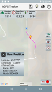
- Your Latitude and Longitude coordinates are given in degrees and in UTM-WSG84 (published in paper maps)
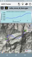
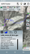
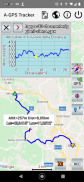
- A track is stored in a GPX file. It can be recorded, stored or loaded to/from memory and shared with other people. Its Elevation vs Distance profile can be shown on the screen.
- Statistics of a loaded GPX track will include the net walk time, ascent and descent altitude.
- A "follow path" monitor function can be enabled to provide an alarm in case you are leaving a loaded GPX path.
It is important to understand that this App is good to trace your path but if you want to measure a walked distance the accuracy is not so good. A distance is measured as the sum of distances among the points acquired every 3sec or 5meters, but GPS accuracy is about 10/20meters, if the path is casual( not like a car that follows a road) the final result can’t be very accurate. Errors up to 15% in the measurement of distances are normal.
Errors are determined by several factors. The most important are:
- quality of received satellite signals, that is poor is the sky is clouded,
- configuration/relative position of satellites that is continuously changing,
- reflections of the signals on large surfaces like walls,buildings, etc.
These are the reasons why GPS may get poor position coordinates when GPS signals are weakened by meteorological conditions and in particular in urban areas, when satellite signals are received from a multi-path propagation due to reflections on buildings.
NOTE:
GPS is used here as a generic term and refers to the capability to receive position data from signals received from satellites. Modern phones can obtain position data from more than one satellite system, i.e. not only the american GPS but also GLONASS, BeiDou and Galileo. A-GPS Tracker will receive data from all the available satellite navigation systems. In addition A-GPS (Assisted GPS) also uses ground sources like cell tower data and WiFi, that may enhance quality and precision when in poor satellite signal conditions and in particular will help to reduce time to start fixing initial position. GPS will be the source of the more accurate position: Latitude, Longitude and Altitude. Note that for hikers Altitude it is of particular importance and can be given only by GPS.
นี่เป็น Tracker กลางแจ้งโดยใช้ความสามารถ A-GPS ของโทรศัพท์ของคุณ หากเปิดใช้งานอาจบันทึกเพลงของคุณได้แม้ว่าโทรศัพท์จะเข้าสู่โหมดเตรียมพร้อม
โดยเฉพาะสำหรับนักเดินทางไกลที่ต้องการบันทึกเส้นทางใหม่หรือต้องการติดตามเส้นทางที่มีอยู่และที่สำคัญกว่านี้ต้องการหลีกเลี่ยงการสูญเสียตัวเองในระหว่างทางกลับ
คุณสมบัติ:
- ระดับความสูงจะสัมพันธ์กับระดับน้ำทะเลปานกลาง (โปรดทราบว่าโปรแกรมหุ่นยนต์ส่วนใหญ่ไม่ทำแบบนี้)
- พิกัด Latitude และ Longitude ของคุณมีการระบุเป็นองศาและใน UTM-WSG84 (เผยแพร่ในแผนที่กระดาษ)
- แทร็คถูกเก็บไว้ในไฟล์ GPX สามารถบันทึกเก็บหรือโหลดข้อมูลจากหน่วยความจำและแชร์กับบุคคลอื่นได้ โปรไฟล์ Elevation VS Distance สามารถแสดงบนหน้าจอได้
- สถิติของแทร็ก GPX ที่โหลดจะมีเวลาในการเดินขึ้น, ความสูงขึ้นและลงมา
- สามารถใช้งานฟังก์ชั่นการตรวจสอบ "ตามเส้นทาง" เพื่อแจ้งเตือนเมื่อคุณออกจากเส้นทาง GPX ที่โหลด
เป็นสิ่งสำคัญที่ต้องเข้าใจว่า App นี้เป็นสิ่งที่ดีในการติดตามเส้นทางของคุณ แต่ถ้าคุณต้องการวัดระยะทางเดินความถูกต้องไม่ดีดังนั้น ระยะทางวัดเป็นระยะทางระหว่างจุดที่ได้รับทุก 3 วินาทีหรือ 5 เมตร แต่ความแม่นยำของ GPS ประมาณ 10 / 20meters ถ้าเส้นทางไม่เป็นทางการ (ไม่เหมือนกับรถที่วิ่งตามถนน) ผลสุดท้ายไม่สามารถทำได้มากนัก ถูกต้อง ข้อผิดพลาดถึง 15% ในการวัดระยะทางเป็นเรื่องปกติ
ข้อผิดพลาดจะพิจารณาจากหลายปัจจัย ที่สำคัญที่สุดคือ:
- คุณภาพของสัญญาณดาวเทียมที่ได้รับที่ไม่ดีคือท้องฟ้าเป็นเมฆ,
- การตั้งค่า / ตำแหน่งสัมพัทธ์ของดาวเทียมที่มีการเปลี่ยนแปลงอย่างต่อเนื่อง
- การสะท้อนของสัญญาณบนพื้นผิวขนาดใหญ่เช่นผนังอาคาร ฯลฯ
นี่เป็นเหตุผลที่จีพีเอสอาจได้รับพิกัดตำแหน่งที่ไม่ดีเมื่อสัญญาณ GPS อ่อนแอลงโดยสภาพทางอุตุนิยมวิทยาและโดยเฉพาะอย่างยิ่งในพื้นที่เขตเมืองเมื่อได้รับสัญญาณดาวเทียมจากการแพร่กระจายหลายเส้นทางเนื่องจากการสะท้อนบนอาคาร
บันทึก:
GPS ใช้ที่นี่เป็นคำทั่วไปและหมายถึงความสามารถในการรับข้อมูลตำแหน่งจากสัญญาณที่ได้รับจากดาวเทียม โทรศัพท์สมัยใหม่สามารถรับข้อมูลตำแหน่งจากระบบดาวเทียมมากกว่าหนึ่งระบบนั่นคือ GPS GLONASS, BeiDou และ Galileo A-GPS Tracker จะได้รับข้อมูลจากระบบนำทางด้วยดาวเทียมทั้งหมด นอกจากนี้ A-GPS (Assisted GPS) ยังใช้แหล่งข้อมูลภาคพื้นดินเช่นข้อมูลของหอสัญญาณโทรศัพท์มือถือและ WiFi ซึ่งอาจเพิ่มคุณภาพและความแม่นยำเมื่ออยู่ในสภาพสัญญาณดาวเทียมที่ไม่ดีและโดยเฉพาะอย่างยิ่งจะช่วยลดเวลาในการเริ่มต้นกำหนดตำแหน่งเริ่มต้น GPS จะเป็นที่มาของตำแหน่งที่ถูกต้องมากขึ้น: ละติจูดลองจิจูดและความสูง โปรดทราบว่าสำหรับนักปีนเขานักสูงอายุมีความสำคัญเป็นพิเศษและสามารถรับได้เฉพาะ GPS เท่านั้น
A-GPS Tracker--เวอร์ชั่น5.5
(21-09-2023)
A-GPS Tracker - ข้อมูล APK
เวอร์ชั่น APK: 5.5แพ็คเกจ: com.giobat.troviamociเวอร์ชั่นล่าสุดของA-GPS Tracker
เวอร์ชั่นอื่น


แอปในประเภทเดียวกัน


